Geoparque Mundial UNESCO

Nº45 – Crags of Vadillo Peraleda de San Román

Geoparque Villuercas > Nº45 – Crags of Vadillo Peraleda de San Román

LOCATION AND ACCESS

The Canchos del Vadillo are located on the left bank of the deep valley of the Gualija river as it passes between the Armorican Quartzite and the underlying formation, “Alternancias Inferiores” with Skolithos of the northern flank of the Guadarranque-Gualija syncline.

It is proposed to reach a viewpoint located just in front of these Canchos and at a higher level. It should be taken into account that a good number of vultures nest on them, which is why it is necessary to have a view of the whole, guaranteeing the ornithological observation of the landscape without our presence altering the normal life of these birds.

We leave the village of Peraleda de San Román along the Dehesilla road that leads to Gualija and about 800 metres from the village we take a left turn that will take us to the area around Risco Sabino. From its pass we descend following the forest track, now in the valley of the Gualija river, without taking any diversions until the track ends. From here we have to descend on foot to get a good panoramic view of the Canchos del Vadillo. It is not advisable to go down very far because we are in an area of very fractured quartzites that leave vertical drops of several metres between their strata, so we must pay close attention to the rocks.

ATTRACTIONS OF THE VISIT

The surroundings of the Canchos del Vadillo provide us with other attractions to complete a full day. We can also visit Geosite 44 beforehand, which includes the Marialina mine, as well as Berrocal de Peraleda (Geosite 43), which is in the same area. The granite boulders that we find before the ascent to the Risco Sabino pass are remarkable and well worth a photographic stop. From this pass we have good views of La Jara Cacereña to the northeast (Valdelacasa Anticline) and of the Guadarranque-Gualija syncline to the southwest, partially covered by the Cenozoic deposits that culminate in the Planchón and La Laguna rañas of early Pleistocene age (A detailed description of the origin of the Rañas can be found in Geosite 5 (Rañas de Cañamero).

Finally, one of the greatest attractions of the Canchos del Vadillo is its ornithological potential. It is a colony of the most representative birds of the quartzite rocky area, including golden eagles, Bonelli’s eagles, griffon vultures, Egyptian vultures, peregrine falcons and other smaller birds.

GEOLOGICAL INTERPRETATION

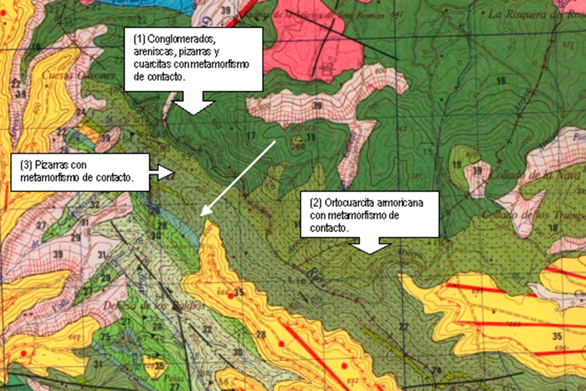
The whole area is within the aura of contact metamorphism with the granitic batholith of Peraleda de San Román, so the materials that can be seen have a certain degree of metamorphism that affects the Armorican quartzite, rocks that make up this immense cliff over a hundred metres high and which extend along both banks of the Gualija river for over eight hundred metres.

The terrain we are walking on from the viewpoint combines conglomerate and sandstone strata that were deposited in continental fluvial environments and the shallow waters of a sea from the Ordovician period, some 485 million years ago. Subsequently, during the Carboniferous period (~330 Ma) an intrusion of granitic magma, the visible result of which is the Berrocal de Peraleda, provided sufficient pressure and temperature to alter the mineralogical and structural composition of all these rocks from the Ordovician marine deposits. This contact metamorphism phenomenon has already been explained in the Geosite 33 “Metamorphic Contact”. A white arrow has been drawn on the geological map indicating the direction in which the Canchos del Vadillo can be seen from the viewpoint.