LOCATION AND ACCESS
To get to the upper course of the Guadalupe river, take a forest track that leaves from the old EX 380 road, in a sharp bend, behind the “Fábrica de la Luz” ruins one kilometre west of Guadalupe.
Geoparque Mundial UNESCO
Geoparque Villuercas > Nº14 – Guadalupe River and Ravine of Valdegracia
To get to the upper course of the Guadalupe river, take a forest track that leaves from the old EX 380 road, in a sharp bend, behind the “Fábrica de la Luz” ruins one kilometre west of Guadalupe.
From the valley we can see the nearby conical Pico Agudo, a quartzite hill that has withstood the effects of the erosion that dismantled the Variscan structure and which is an extension of the Viejas Syncline.
The Guadalupe river, from its source in the Los Hollicios rocky outcrops in the southern part of La Villuerca to its origins in the river Guadiana near Valdecaballeros, has natural values of notable importance from a geological, ecological and landscape point of view. It is worth highlighting the perfect state of conservation of the upper section of the river, which has been protected as an Ecological and Biodiversity Corridor since 2003, where we can find plant formations of great importance, such as the riverside galleries of willows, ashes, poplars and alders, or those associated with the banks, generally grass pastures and mixed forests of holm oaks and cork oaks.
The corridor is home to a large number of protected mammal and bird species: otter, shrew, wild cat, marten, black stork, eagle owl, scops owl, booted eagle and short-toed eagle, kites, black-winged kites, goshawk, sparrowhawk, kestrel, as well as a large number of waterfowl.
In the area of the Mato reservoir there are good views of the monumental Palace of La Granja de Mirabel (14th century), a National Monument and Site of Cultural Interest, and in terms of ethnographic heritage, there is an abundance of mills, hammer mills, fulling mills and mills built by the Hieronymite monks on the banks of the Guadalupe river. The mills under the great buttress dam of El Estanque, the oldest in Europe and declared an Asset of Cultural Interest, stand out among them all. The German traveller Hieronymus Münzer, in his Itinerarium Hispanicum of 1494-1495, informs us that Queen Isabella the Catholic spoke of the beautiful and exuberant surroundings of Guadalupe as “her paradise”.
The monastic Guadalupe village, with its Royal Monastery of Santa María de Guadalupe, a jewel of Mudejar Gothic style and the most important former peninsular pilgrimage centre in the Kingdom of Castile, was declared a World Heritage Site by UNESCO in 1993.
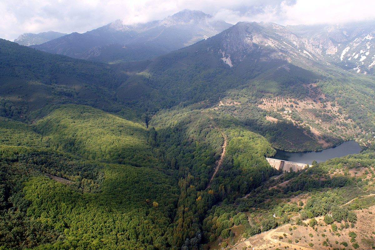
The source of the Guadalupe river is located in the Hollicios scree slopes at the core of the Viejas syncline, partially dismantled to the south with some outcrops such as Pico Agudo and Las Amoladeras. The contact between the fractured and permeable Armorican Quartzite that forms the elevated parts of syncline and the underlying impermeable Ibor Group gives rise to the important aquifers that feeds the river (see also Geosite 41).
The rest of the materials that make up the valleys of these riverbeds correspond to the older basement, which has been exposed by the erosion of the large Variscan structure that formed the Ibor Anticline. The Ibor Group is located at the head of the river and lithologically it is made up of finely laminated shaly strata, although there are frequent intercalations of sandstones, conglomerates and discontinuous levels of dolomitic limestone which can reach 25 m in thickness and which outcrop in the vicinity of the Palacio de Mirabel, next to some old lime kilns, where they were exploited together with those of La Calera (Geosite 8) in order to build the Palacio de Mirabel and the historic Monastery of Guadalupe.
In the shaly rocks of the Ibor Group, it is common to find abundant remains of algal filaments -vendotaenids-, and the limestones usually show stromatolitic structures produced by microbial mats. In other areas, these carbonate levels include the first metazoans that secreted a calcareous exoskeleton (Cloudina). All sediments of the Ibor Group were deposited in a mixed marine platform environment (siliciclastic and carbonate).
The course of the river runs for the most part through the oldest materials in the geopark, represented by the Domo Extremeño Group, of an imprecise Ediacaran age, as it contains no fossils. The Domo Extremeño Group, represented here by the Guadiana Formation, includes very monotonous series of alternating shales and greywackes that were deposited by turbidites in deep marine environments. They represent sediments strongly folded by the Cadomian orogeny on which the Ibor Group is discordant. The important clayey matrix present in the greywackes, together with the abundant organic matter and pyrite present in both greywackes and shales, favour their easy weathering and erosion. These rocks are widely represented in the southeast of the Geopark (Guadalupe and Alía), giving rise to the lowest and smoothest topography.
This area has strong relief to the north, due to recent faults of some importance originating during the final phase of the Alpine orogeny, and which constitute the watershed between the river basins of the Tagus to the north and the Guadiana to the south.